Property Record
30 Falcon Rd, Hillsborough, NJ 08844
Current Lease Availabilities
NEARBY LISTINGS FOR SALE OR LEASE
Property Detail
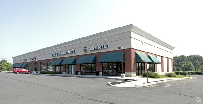
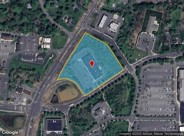
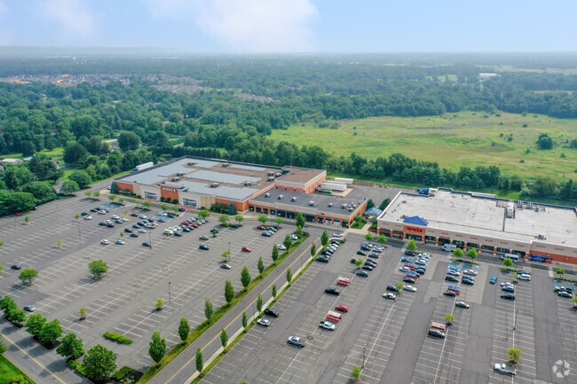
30 Falcon Rd
Newark, NJ-PA
ADDITIONAL LOTS: SALAD WORKS MALL
10-00182-01-00001
Somerset
Storebuilding
New Jersey
X
1
34035C0144E
5.39 AC
2024
Princeton North
2025
Northern New Jersey
053806
DEMOGRAPHICS near 30 Falcon Rd
1 Mile
3 Mile
5 Mile
2024 Total Population
8,196
43,474
111,650
2029 Population
8,247
43,368
112,040
Pop Growth 2024-2029
+ 0.62%
(0.24%)
+ 0.35%
Average Age
41
41
42
2024 Total Households
3,189
16,144
41,638
HH Growth 2024-2029
+ 0.56%
(0.27%)
+ 0.38%
Median Household Inc
$106,085
$121,931
$121,671
Avg Household Size
2.50
2.60
2.60
2024 Avg HH Vehicles
2.00
2.00
2.00
Median Home Value
$362,939
$398,896
$436,921
Median Year Built
1983
1982
1982
Nearby Places
- Restaurants
- Banks
- Shops
- Fitness
- Groceries
PUBLIC TRANSPORTATION
COMMUTER RAIL
Somerville (Raritan Valley Line - NJ Transit Commuter Rail (NJ Transit))
DRIVE
WALK
Distance
Somerville (Raritan Valley Line - NJ Transit Commuter Rail (NJ Transit))
7 min
3.9 mi
Raritan (Raritan Valley Line - NJ Transit Commuter Rail (NJ Transit))
DRIVE
WALK
Distance
Raritan (Raritan Valley Line - NJ Transit Commuter Rail (NJ Transit))
8 min
5.0 mi
AIRPORT
Trenton Mercer
DRIVE
WALK
Distance
Trenton Mercer
42 min
26.0 mi
Newark Liberty International
DRIVE
WALK
Distance
Newark Liberty International
48 min
38.6 mi
Freight Ports
New York Container Terminal
DRIVE
WALK
Distance
New York Container Terminal
48 min
35.2 mi
Nearby Properties
Address
Land Use
TOTAL SIZE
Lot Size
Zoning
Address
Land Use
TOTAL SIZE
Lot Size
Zoning
19,528 SF
52.97 AC
02
Address
Land Use
TOTAL SIZE
Lot Size
Zoning
289,939 SF
27.31 AC
MUID
Address
Land Use
TOTAL SIZE
Lot Size
Zoning
14.06 AC
GV
Address
Land Use
TOTAL SIZE
Lot Size
Zoning
61,757 SF
8.75 AC
TC
Address
Land Use
TOTAL SIZE
Lot Size
Zoning
27.06 AC
GV
Address
Land Use
TOTAL SIZE
Lot Size
Zoning
Address
Land Use
TOTAL SIZE
Lot Size
Zoning
48 AC
R1
Address
Land Use
TOTAL SIZE
Lot Size
Zoning
111,204 SF
26.68 AC
PD
Address
Land Use
TOTAL SIZE
Lot Size
Zoning
1,383 SF
259.46 AC
ED
Address
Land Use
TOTAL SIZE
Lot Size
Zoning
43.66 AC
ARPD
Address
Land Use
TOTAL SIZE
Lot Size
Zoning
780 SF
9.89 AC
GA
Address
Land Use
TOTAL SIZE
Lot Size
Zoning
32.08 AC
R
Address
Land Use
TOTAL SIZE
Lot Size
Zoning
1,440 SF
19.33 AC
TC
Address
Land Use
TOTAL SIZE
Lot Size
Zoning
1,096 SF
17.75 AC
TC
Address
Land Use
TOTAL SIZE
Lot Size
Zoning
413,403 SF
68.15 AC
LI
Address
Land Use
TOTAL SIZE
Lot Size
Zoning
22.95 AC
ARPD
Address
Land Use
TOTAL SIZE
Lot Size
Zoning
27.10 AC
Address
Land Use
TOTAL SIZE
Lot Size
Zoning
186,180 SF
16.41 AC
PD
Address
Land Use
TOTAL SIZE
Lot Size
Zoning
49.42 AC
R
Address
Land Use
TOTAL SIZE
Lot Size
Zoning
424.28 AC
CDZ
Address
Land Use
TOTAL SIZE
Lot Size
Zoning
12.90 AC
TC
Address
Land Use
TOTAL SIZE
Lot Size
Zoning
138,253 SF
4.99 AC
GV
Address
Land Use
TOTAL SIZE
Lot Size
Zoning
4.06 AC
HS
Address
Land Use
TOTAL SIZE
Lot Size
Zoning
Address
Land Use
TOTAL SIZE
Lot Size
Zoning
Address
Land Use
TOTAL SIZE
Lot Size
Zoning
1,854 SF
8.67 AC
HS
Address
Land Use
TOTAL SIZE
Lot Size
Zoning
666 SF
7.43 AC
GA
Address
Land Use
TOTAL SIZE
Lot Size
Zoning
3.40 AC
GA
Address
Land Use
TOTAL SIZE
Lot Size
Zoning
10,580 SF
4.86 AC
PD
Address
Land Use
TOTAL SIZE
Lot Size
Zoning
970 SF
40.45 AC
R1
The World's #1 Commercial Real Estate Marketplace
Connect with us
© 2025 CoStar Group
The information above has been obtained from sources believed reliable. While we do not doubt its accuracy we have not verified it and make no guarantee, warranty or representation about it. It is your responsibility to independently confirm its accuracy and completeness. Any projections, opinions, assumptions, or estimates used are for example only and do not represent the current or future performance of the property. The value of this transaction to you depends on tax and other factors which should be evaluated by your tax, financial, and legal advisors. You and your advisors should conduct a careful, independent investigation of the property to determine to your satisfaction the suitability of the property for your needs.